Laguna de Alegría, Usulután7 min read
Overlanding to Laguna de Alegría: the highlands nobody sells you
Everyone points you at the surf. The best driving in El Salvador is two hours inland, up a coffee road into a volcanic crater.
- Best time to go
- Dry season, so the crater road stays simple. Mornings are clearest — afternoon mist comes in and the temperature drops fast.
- Getting there
- Leave the Panamericana at Santiago de María and climb through the coffee farms. About 2h15 from San Salvador, longer and better if you come off the coast.
- Cost
- A small entrance fee at the lagoon, a dollar or two to park. Fuel is easy to find the whole way.
- How long
- Overnight — it is a poor day trip and a good stopover
Don't miss
- The climb from Santiago de María through the Tecapa coffee slopes
- A flat gravel apron on the crater floor, wide enough to park and camp on
- Green-turquoise water held by dissolved sulphur, not algae
- Coast to crater in about two hours — the case for driving El Salvador
Every guide to El Salvador sells you the coast. Surf City, the point breaks, the sunset over the Pacific — all of it earned, none of it the whole country. Turn inland and climb, and within two hours you are in cold air on the rim of a volcanic crater, which almost nobody's itinerary includes.
The road up to Laguna de Alegría is the best argument for driving this country instead of flying between bits of it.
The road up
You leave the Panamericana at Santiago de María and start climbing. The road narrows, the switchbacks tighten, and the whole way up you are driving through coffee farms — shade trees, pickers' tracks, drying patios at the roadside. It is not a technical road in the dry season. It is a slow one, and it is the good part.
What you notice is the temperature. You can start the morning in the humidity at El Sunzal and be standing in air that needs a jacket by the afternoon, at around 1,200 m on the flank of the Tecapa volcano. Alegría is one of the coldest towns in El Salvador, and after a week on the coast that is a novelty rather than a hardship.
What is at the top
The lagoon sits in the crater above the town. The water is an opaque green-turquoise that comes from dissolved sulphur and minerals seeping up from the volcano, not from algae, which is why the colour holds all year. You will smell it before you see it, and there are seeps around the shore where the ground is warm to the touch.
Locals call it la Esmeralda de América, the Emerald of America. That is the kind of nickname that usually oversells a place, and here it roughly describes it.
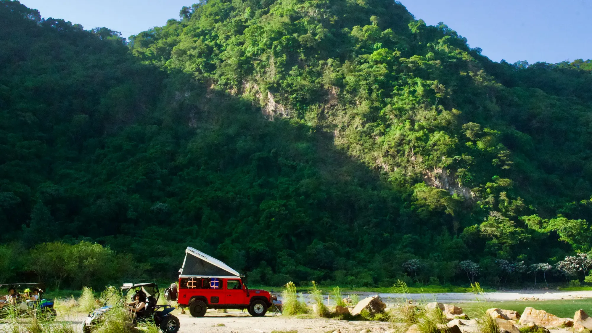
For anyone travelling in a vehicle, the useful detail is the shore itself: a broad, flat apron of pale gravel and rounded boulders on the crater floor, wide enough to park on, with the forested crater wall going up steeply behind. It is one of the more improbable places in the country to open a roof tent.
Why El Salvador suits overlanding
The case is mostly about scale. The country is small enough that the drive between two completely different landscapes is an afternoon, not a travel day — world-class waves in the morning, a sulphur crater at altitude by evening. Nowhere else in Central America compresses that much variety into that little distance.
The practicalities hold up too. The roads that matter are paved, fuel is easy to find, signage is adequate, and navigation is straightforward enough that you do not need a fixer or a convoy. Distances are short enough that a wrong turn costs you twenty minutes rather than a day.
The part that is harder to plan for
The reception. A foreign-plated vehicle draws attention everywhere, and in El Salvador that attention is almost entirely people waving at you. It is more pronounced in the east, where far fewer overlanders come through — you are a novelty in Usulután in a way you are not in La Libertad. Budget time for the coffee stop where somebody wants to ask about the truck.
Building a route around it
Alegría works best as the turnaround point of an eastern loop rather than a day trip. Come off the coast, climb at Santiago de María, stay the night up top, and come down through the Tecapa coffee slopes in the morning. Pair it with Santiago de María itself, or push further east if you have the days.
Do it in the dry season if you want the crater road to be simple. Mornings are clearest; the afternoon mist comes in and the temperature drops fast.
Whose route this is
Fred is the truck. That is worth saying first, because the caption on the original photographs reads like a person is being winched up a mountain road: Fred is a red Land Rover Defender with a pop-top roof tent, and he belongs to @fredsinviadi.
The trip is a long one — north to south down the Pan-American corridor, from Canada and the United States through Mexico and Baja, then Belize, Guatemala, El Salvador, Honduras and Nicaragua, on toward Costa Rica. El Salvador sits in the middle of that, which is the reason their read on it carries weight. When people who have driven most of a continent say the surprise was a coffee road in Usulután rather than the coast everyone photographs, that is not first-week enthusiasm.
It is also a useful corrective to how this country gets sold. The El Salvador in the brochures is 40 km of coastline. The El Salvador you find with a vehicle and a spare day is a great deal larger than that, and most of it is uphill.
Find it
Laguna de Alegría · Alegría · Usulután, El Salvador
- Coordinates
13.5122, -88.4897- Elevation
- 1,200 m
- Overlanding
- Volcanoes
- Off the path